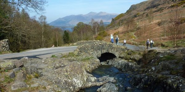
Windermere Circuit drive
A drive of contrasts around England’s largest lake, Windermere. The route visits some of the most popular attractions in Lakeland and also some relatively remote and peaceful parts on the western shore. The scenery is fabulous throughout. 31 miles.
Route Map
Summary of main attractions on route
| Distance | Attraction | Car Park Coordinates |
| 0 miles | Waterhead, Ambleside | N 54.42116, W 2.96284 |
| 2.1 miles | Brockhole Visitor Centre | N 54.40120, W 2.93914 |
| 4.3 miles | Rayrigg Meadow picnic site | N 54.37897, W 2.91924 |
| 5.3 miles | Bowness-on-Windermere | N 54.36591, W 2.91993 |
| 7.6 miles | Blackwell House | N 54.34286, W 2.92214 |
| 9.5 miles | Beech Hill picnic site | N 54.32014, W 2.94117 |
| 12.5 miles | Fell Foot park | N 54.27621, W 2.94987 |
| 15.1 miles | Lakeside, Windermere | N 54.27882, W 2.95697 |
| 15.9 miles | Stott Park Bobbin Mill | N 54.28541, W 2.96517 |
| 21.0 miles | Esthwaite Water | N 54.35029, W 2.98460 |
| 21.9 miles | Hill Top, Near Sawrey | N 54.35247, W 2.97133 |
| 24.1 miles | Hawkshead Village | N 54.37410, W 2.99679 |
| 27.1 miles | Wray Castle | N 54.39822, W 2.96968 |
| 30.8 miles | Waterhead, Ambleside | N 54.42116, W 2.96284 |
The attraction car park coordinates are available as Points Of Interest (POI) files for your sat nav device. Use the following link to download a zip file containing the most common POI file formats; Windermere Circuit POI. Further information on sat nav files can be found on the Navigation page.
The Drive
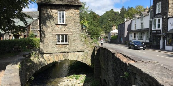
Waterhead, Ambleside

Distance: 0 miles
Location: Waterhead car park, Ambleside
Coordinates: N 54.42116, W 2.96284
As the name suggests, Waterhead marks the head of Windermere lake and you will find quite a few attractions in this attractive village near to Ambleside town. The most obvious feature is the lake and there is plenty of shoreline access with excellent views across the water. The small promenade opposite the car park makes a pleasant stroll and there are a few benches from where you can watch the boats coming and going. Windermere Lake Cruises call at the main pier here and you can take a scenic red cruise to Bowness and Lakeside or a seasonal Green cruise to nearby Wray Castle and Brockhole.
Also near the car park is the Wateredge Inn which has a fabulous beer garden overlooking the lake. If you walk beyond the pub you soon come to Borrans Park which provides good open grassy areas and small shingle beaches overlooking the lake. Beyond the park is Ambleside Roman Fort which was probably built during the reign of the Emperor Hadrian (AD 117–138), around the same time as Hadrian’s Wall was built in north Cumbria. It is free entry to the fort and although not much remains of it now, you can still see the foundations of the various buildings, with information boards around the site telling you more. The Romans certainly had a magnificent view from their fort with mountain and lake scenery all around.
It is about 20 minute walk from Waterhead to Ambleside town, or a short driving detour, if you want to explore the attractions there. There are many tourist shops, outdoor specialists, cafes, restaurants and pubs, plus the fascinating Armitt Museum which includes a display of beautiful botanical drawings and watercolours from Beatrix Potter.
The Waterhead car park is pay and display with toilet facilities. Beware, there are camera’s in the car park so don’t stay too long without paying! There are a few small gift shops, stalls and cafes in the Waterhead area.
Travelling
Leave the car park and turn left on the A5075 towards Windermere town. This soon meets the A591 at traffic lights where you turn right to continue along the picturesque lake shore road. As you leave Waterhead, the peaceful and attractive Stagshaw Gardens are on the left and approx 0.6 miles beyond is the Low Wood Hotel which is well known for water sports in a spectacular setting. Continue on for approx 0.8 miles to Brockhole visitor centre on the right.
Brockhole Visitor Centre

Distance: 2.1 miles
Location: Brockhole Visitor Centre
Coordinates: N 54.40120, W 2.93914
Brockhole is the main visitor centre for the Lake District, where finding out about the National Park is only part of a fabulous visitor experience with many different attractions for the whole family on the shores of Windermere lake.
The main building and gardens were actually built as a private home in the late 19th century, one of many holiday or retirement homes built around the lake in the Victoria era for wealthy city industrialists. Some are still private homes today but many are now hotels or visitor attractions. As a private home, Beatrix Potter was a frequent visitor being related to the owners. After 1946 it was sold and became a nursing home until 1966 when it was bought by the Lake District National Park Authority who opened it to the public in 1969 as the UK’s first National Park visitor centre.
Inside the house are exhibitions of the local area, a gift shop and information centre plus a restaurant and cafe where you can sit on the terrace overlooking the gardens. Outside there are plenty of different activities for visitors including boat hire on the lake, archery and an adventure playground. In the trees above the car park you can see the treetop adventure which ends in an impressive zip line. If you don’t fancy anything too strenuous you can just stroll around the wonderful 30 acres of grounds and formal gardens which are beautifully kept all year round. The footpath also follows the shingle lakeshore between trees with great views across the lake and various boat jetties. Windermere Lake Cruises land here on the red cruise between Bowness and Waterhead, plus the seasonal Green cruise between Waterhead and Wray Castle across the lake. There are additional stalls in the grounds where you can get refreshments and picnic tables near the lake.
There is a charge for activities and parking. Entrance to the visitor centre is free and includes toilet facilities. Attractions are open daily all year.
Travelling
From Brockhole car park, turn right on the A591 towards Windermere town. After approx 1 mile, pass through Troutbeck Bridge village where there is a service station & shop. Continue past Troutbeck Bridge for approx 0.5 miles to the mini-roundabout and turn right on the A592 towards Bowness. Shortly, Hammarbank pay and display car park is on the right with good views over the lake. Continue beyond this, down the steep hill and around a couple of bends to Rayrigg Meadow car park on the right.
Rayrigg Meadow

Distance: 4.3 miles
Location: Rayrigg Meadow picnic site
Coordinates: N 54.37897, W 2.91924
Rayrigg Meadow is a pleasant recreational area next to Windermere lake with various attractions for visitors. Near to the car park is a good picnic and play area with adjacent grass in an open setting. The small grassy hill above the car park is known as Queen Adelaide’s hill and the summit provides wonderful views across the lake and towards the mountains in the distance. Queen Adelaide apparently visited this fabulous viewpoint in 1840 and the hill was renamed in her honour from its original Rayrigg Bank. It is a short but steep footpath to the top from the car park.
Towards the lake from the play area is a well placed bench overlooking the lake and a short drop down brings you to the tree-lined lakeshore where there are shingle beaches and a couple of boat jetties with attractive views across the water. There is a footpath along the lakeshore in both directions, if you turn right you soon reach Millerground which again has a few jetties and lovely views from the shingle shore. The easy access along all this lakeshore makes it a good place for paddling and bathing with the added benefit of fine sunset views across the lake.
The car park is pay and display with adjacent toilet facilities.
Travelling
Turn right out of the car park and continue on the A592 towards Bowness. After approx 0.6 miles, pass the impressive Windermere Jetty Museum where you can learn all about the last 200 years of Windermere’s boating history, with fascinating displays and many historic boats. Beyond this, enter the outskirts of Bowness and shortly on the right is Rayrigg Road car park, ideally placed to visit the town.
Bowness-on-Windermere
Distance: 5.3 miles
Location: Bowness-on-Windermere, Rayrigg Road car park
Coordinates: N 54.36591, W 2.91993
Bowness is an attractive and very popular tourist town on the shores of Windermere lake. Until the mid-1800’s it was a small peaceful village but all that changed with the opening of the railway line from Kendal to nearby Windermere town in 1847. Victorian tourists started pouring in to the area and the towns of Windermere and Bowness grew massively to meet the tourist demand. Nowadays the two towns merge together and are regularly filled with tourist crowds but Bowness still retains a lot of charm by the lake with plenty of attractions and is worth exploring.
One of the most popular attractions is The World of Beatrix Potter, opposite the car park. The famous children’s author wrote 23 enchanting little books in the early 1900’s, with characters such as Peter Rabbit, Squirrel Nutkin and Jemima Puddle-Duck still much loved across the world. This popular family attraction recreates 3D scenes from the stories which mesmerizes children and adults alike. The town centre itself is nearby and has numerous shops, cafes and pubs where you can easily spend some time exploring before wondering down past St Martin’s Church to the nearby lakeside area.

The picturesque lakeside area overlooking Bowness Bay is slightly separate to the town centre but often just as busy. There are a number of jetties where you can catch one of the many Windermere Lake Cruises. Beyond the jetties is Glebe Road which forms a popular loop along the lake shore. Within this loop is a large open recreational area known as The Glebe. The grassy area provides lovely views up the lake and there are various activities available such as mini golf and tennis. Beyond The Glebe is Cockshott Point which also has some good open grassy areas with shingle beaches and a footpath along the attractive lakeshore. There are a number of shops, kiosks, cafes and pubs around the lakeside area. Rayrigg Road car park is pay and display with toilet facilities.
Travelling
Leave the car park at the exit and turn right on the minor road, then soon right again on the A592 towards Bowness centre. Shortly, approach a mini-roundabout and turn right towards the lake, still the A592. Drop down the hill to enter the lakeside area. After a short distance the main road turns away from the lake but you can take the right turn here and follow the Glebe Road loop which gives some good views of the lake as you pass various shops and cafes. Additional parking is available here.
The road soon brings you back to the A592 where you turn right and soon pass the road to the Windermere Ferry on the right, with a large marina also on the right. Just beyond the ferry road, take the left turn which is the B5284 towards Kendal. Continue up the steep hill to a T junction where you turn right on the A5074. The road then passes some exclusive properties and impressive hotels, well hidden from the road but with great views over the lake. After approx 0.6 miles, take the B5360 on the right towards Newby Bridge. In a short distance the first entrance on the right is Blackwell House.
Blackwell House
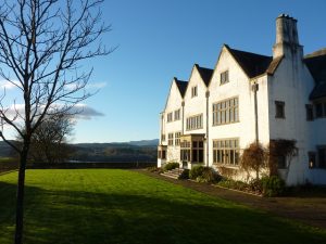
Distance: 7.6 miles
Location: Blackwell House
Coordinates: N 54.34286, W 2.92214
The iconic Blackwell House overlooking Windermere lake is a beautiful and rare example of Arts and Crafts architecture. The Arts and Crafts ethos evolved around simple architecture, decorative artwork, nature and light with high quality materials and local craftsmen who would handcraft as much as possible. The house was built in 1900 as a holiday home for Manchester brewery owner Sir Edward Holt, around the same time as a number of other big houses were built for wealthy city industrialists in the area. After the death of Sir Edward Holt and then his wife, the house became a school during the second world war until 1976 after which it was used as offices. After an uncertain couple of years lying empty, it was purchased and restored by the Lakeland Arts Trust in 1999 before opening to the public in 2001.
You can explore the large fascinating house which was designed by Mackay Hugh Baillie Scott, an influential figure in the Arts and Crafts movement at the time. Outside are lovely terraced gardens which were designed by the renowned landscape architect Thomas Mawson who lived locally and also designed a number of other well known and popular gardens around Windermere. The house and gardens are in a wonderful setting high above Windermere lake and there are excellent views across the water towards the Coniston mountains in the distance. The views can also be appreciated from the cafe which spills out on to an outdoor terrace in good weather.
Inside the house is a gift shop and toilets. The house and gardens are open daily all year with a charge for entry. Closed early January. Parking plus access to the cafe and gift shop are all free.
Travelling
Leave the car park and turn right on the B5360. Continue for approx 1 mile through pleasant countryside and woodland to a T junction with the A592 where you turn left. After approx 0.8 miles, pass the prominent Beech Hill Hotel on the right and just after this is Beech Hill picnic site, also on the right.
Beech Hill picnic site
Distance: 9.5 miles
Location: Beech Hill picnic site
Coordinates: N 54.32014, W 2.94117
Beech Hill picnic site has a small raised grassy area with picnic tables overlooking Windermere lake. There are good views towards the wooded hills on the opposite side of the lake and the central Lakeland mountains beyond. You can also access the lakeshore here where there is a small shingle beach inbetween trees, although it is down a steep footpath with many steps from the picnic area. Being a little out of the way, the picnic site is often relatively quiet and is a good place to enjoy the scenery. The large car park is pay and display and has seasonal toilets but no other facilities. Beech Hill hotel is next door.
Travelling
Turn right out of the car park on the A592. Just ahead is a large layby on the right with good views over the lake. The road continues through woodland towards Newby Bridge. Although you are never far from the lake, it is mostly obscured from view by trees. After approx 3 miles, the road approaches the end of the lake and the view opens up a little. Shortly on the right is the entrance gate to Fell Foot Park.
Fell Foot Park
Distance: 12.9 miles
Location: Fell Foot Park
Coordinates: N 54.27621, W 2.94987
Fell Foot Park is an attractive National Trust owned parkland on Windermere lakeshore with a number of activities for visitors. Originally, it was one of many private estates around the lake with a mansion house for a wealthy landowner. The wonderful gardens were established in the mid-19th century, along with the Victorian gothic style boathouses and piers that are now used for the cafe and boat hire. The mansion was demolished in the early 20th century in anticipation of a larger house, but that never happened and the site was largely abandoned for a time before being donated to the National Trust in 1948. It was then used as a campsite before opening as a Country Park in 1972.
Many people come to Fell Foot to picnic, play and paddle. There are plenty of grassy areas by the water with picnic tables dotted around. From the waters edge there are fantastic views up the lake towards the mountains in the distance. The lake is narrow at this point and it soon becomes the River Leven downstream. Boating is also popular and you can hire kayaks, rowboats and paddleboards. Windermere Lake Cruises operate a small passenger ferry between May and September which regularly travels the short distance to Lakeside across the lake.
There are some good footpaths around the mature gardens which stretch to open meadows downstream. As well as the cafe, other facilities include an adventure playground and toilets. There is free entry to the Park which, along with the cafe, is open daily all year. The car park is National Trust pay and display.
Travelling
Exit the car park by the one way system and turn right on the A592 towards Newby Bridge. After approx 0.8 miles, meet a big roundabout and take the second exit which is the main A590. Soon pass the Newby Bridge Hotel on the left which was another historic mansion house. Just beyond that, take the right turn towards Lakeside which immediately crosses the old and narrow Newby bridge with the River Leven underneath draining Windermere lake. Just over the bridge on the right is the Swan Hotel which provides refreshments in a pleasant riverside setting. Beyond that you pass over the Lakeside & Haverthwaite Railway and continue for approx 1 mile on a narrower road through woodland to the village of Lakeside. Just before the Lakeside Hotel on the right, turn right to Lakeside car park.
Lakeside, Windermere

Distance: 15.1 miles
Location: Lakeside, Windermere
Coordinates: N 54.27882, W 2.95697
Lakeside on Windermere is a small but popular area with some excellent attractions by the lake. The main feature is the Lakeside pier and railway station which is the historic terminus for both Windermere Lake Cruises and The Lakeside & Haverthwaite Railway.
Pleasure cruises on Windermere started in 1845 and have continued ever since. Nowadays, roughly every hour and every day between Easter and November, a steamer boat leaves Lakeside for the scenic 40 minute trip up the lake to Bowness, and on to Waterhead Ambleside. There are still boats in winter but less frequent. There is also a seasonal ferry boat from here to picturesque Fell Foot Park across the lake.
The railway spur to Lakeside from the main Furness line at Ulverston was completed in 1869 and Lakeside pier soon became a busy little port with trains and boats carrying passengers and goods. The line was eventually closed in 1967, but the Lakeside to Haverthwaite section was reopened in 1973 as a heritage railway. Nowadays, it is a delightful 3.5 mile line, with steam trains chugging through the attractive Leven valley and period carriages giving a real sense of the old days. Trains are timed to meet the boats for an enjoyable train & boat ride in season, with a very limited service outside of that period.
Adjacent to the pier and station is the Lakes Aquarium which contains wonderful displays of fish, reptiles and even otters. It provides a fun and interesting visit for all the family, especially in wet weather as it’s all indoors!
From the pier there are pleasant views across the lake towards Fell Foot and Gummer’s How hill, plus up the lake towards Lake District mountains in the far distance. There is a cafe on the pier which provides refreshments overlooking the lake, as does the adjacent Lakeside Hotel. The car park is pay and display with nearby toilet facilities.
Travelling
Head to the car park exit, adjacent to the Lakeside Hotel, and turn right towards Hawkshead. The road continues through Lakeside village with a few narrow twists and turns. In just over 0.5 miles, Stott Park Bobbin Mill is on the left, with a small car park at the front and a bigger one up the lane on the left before the mill.
Stott Park Bobbin Mill

Distance: 15.9 miles
Location: Stott Park Bobbin Mill
Coordinates: N 54.28541, W 2.96517
The original Stott Park Bobbin Mill dates from 1835 and was built to produce wooden bobbins (or thread spools) for the Lancashire textile mills during their heyday following the Industrial revolution. A massive amount of these bobbins were required and the Lake District proved to be a good place to make them with an abundant supply of water to power the machinery and also the coppice wood that was used for the bobbins. Up to 250,000 bobbins per week were produced in this small mill alone. The industry flourished throughout the 19th century and there were over 100 Lakeland bobbin mills over that period but Stott Park is the only surviving example and is now managed by English Heritage.
You can take a fascinating guided tour of the mill and still see a few bobbins being made on the original belt driven lathes. Electricity provides power nowadays but originally it was all water powered with a steam engine later added. You can still see the impressive steam engine which is powered up on bank holidays and special events. Outside, you can see the stream that provided the power with pleasant footpaths around the grounds and a picnic area. Displays around the site tell you more about its history and other interesting facts.
There are toilet facilities and a small shop where you can buy bobbins made in the mill. There is a charge for entrance and parking if you are not English Heritage members. The attraction is open Wednesday to Sunday plus bank holidays between Easter and November. Closed during winter.
Travelling
Return to the road and turn left, heading north towards Hawkshead. This area is normally relatively peaceful as the road meanders between trees, meadows and pastures. The trees mostly hide any views of the nearby lake and beyond, but the immediate surroundings are very pleasant. After approx 2 miles, Graythwaite Hall is on the left and its lovely gardens are open from April to August, often at their best in the spring. Continue through wonderful countryside and woodland for approx 2.7 miles to meet the wooded shores of Esthwaite Water, the visitor centre car park is just beyond on the right
Esthwaite Water
Distance: 21.0 miles
Location: Esthwaite Water visitor centre
Coordinates: N 54.35029, W 2.98460
Esthwaite Water is one of the lesser known Lake District lakes, probably due to it being the only privately owned one with very little public access. However, it is still very attractive and is worth some exploring. This small visitor centre, set in woodland on the lakeshore with lovely views up the lake, offers a number of attractions for visitors and has developed from the original trout fishery. It remains a popular venue for fishing, boats and kit can be hired for this activity. Also on offer is an Osprey Safari where you can self-drive a small electric boat around the lake looking for the Ospreys that are normally in residence between April and September. At any time of year the boat ride gives a great view of the different wildlife on and around the peaceful lake.
The lake was a treasured place for Beatrix Potter, being so close to her house at Hill Top, and for the famous poet William Wordsworth, who went to school in nearby Hawkshead. No doubt the lake and surroundings gave them both plenty of inspiration for their interests as they explored it.
The visitor centre is a 2 minute walk from the main car park along the shingle shore and there are a few picnic tables around the car park. The small Boathouse cafe at the visitor centre provides refreshments with an attractive terrace overlooking the lake and nearby toilets. Open all year. The car park is pay and display.
Travelling
Leave Esthwaite Water car park and turn left. Very shortly take the left turn to Sawrey. The narrow road follows the wooded shores of Esthwaite Water before climbing a short distance to the village of Near Sawrey. Soon meet a T junction in the village where you turn right and Hill Top car park is immediately on the right.
Hill Top, Near Sawrey

Distance: 21.9 miles
Location: Hill Top, Near Sawrey
Coordinates: N 54.35247, W 2.97133
Hill Top, in the attractive village of Near Sawrey, was once the home and sanctuary of Beatrix Potter and is still kept exactly as it would have been when she lived and worked there.
Born in London in 1866, Beatrix Potter is known across the world nowadays as the famous children’s author who produced 23 little story books with much loved characters such as Peter Rabbit and Jemima Puddleduck. What many don’t realise is just how talented and influential she was in many other varied fields, from land conservation and sheep farming to the science behind fungi.
Hill Top was bought by Beatrix in 1905 with profits from her early work. At that time she still lived in London, this was her bolthole and sanctuary where she could escape to write her books. Even when she married in 1913 and moved in to nearby Castle Farm she continued to use Hill Top for her personal work and pleasure. Today the house is kept very much as she left it when it was donated to the National Trust after her death in 1943. Very atmospheric and filled with her personal possessions, you can get a real sense of her life and guides will tell you more. The garden is also wonderful and, along with the house and other nearby locations, provided Beatrix with many illustrations used in her books.
Hill Top is a short walk along the road from the car park. The house is open daily, except Fridays, from February to November, plus Fridays in school holidays. Closed in winter. There is an admission fee to house and gardens, free for National Trust members. The ticket office is in the car park. The house can be busy so entry is by timed ticket and booking recommended. Outside there are attractive gardens, a small gift shop, toilets and occasionally a pop up cafe. The small car park is free for visitors to the property. The Tower Bank Arms next door is a quaint looking pub which also has connections with Beatrix Potter.
Travelling
From Hill Top car park, turn left on the B5285 towards Hawkshead. The road soon follows the picturesque eastern shore of Esthwaite Water with good views between the trees, across the water towards the hills beyond. Just beyond the lake, the road bends to the left and the village of Hawkshead is ahead. Take the right turn to Hawkshead village, still the B5285, then very soon the first left turn brings you to the village car park on the left.
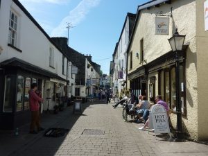
Hawkshead
Distance: 24.1 miles
Location: Hawkshead Village car park
Coordinates: N 54.37410, W 2.99679
Hawkshead is one of the most charming villages in the Lake District and worth a stop to explore its historic centre. The village dates back to medieval times, originally a prosperous wool market run by the monks of Furness Abbey which was near Barrow-in-Furness. There are a number of historic buildings around the village, including Hawkshead Grammar School which was founded here in 1585 and educated a number of notable pupils, including the famous local poet William Wordsworth who was sent here in 1778, aged 8, after his mother died. The school eventually closed in 1909 and the building is now a museum dedicated to its interesting history.
Also in the centre of the village is the National Trusts Beatrix Potter Gallery, a 17th century building housing displays of her famous watercolour illustrations and more about her work. The building was once the office of the solicitors W.H. Heelis & Son, where William Heelis worked when he married Beatrix in 1913. No doubt Beatrix would have spent a great deal of time in and around Hawkshead when she lived nearby at Hill Top. Other notable buildings in the village include St Michael and All Angels church, most of which dates back to the 16th century and sits on the small hill overlooking the village. There is a lovely churchyard where you can find some peace and enjoy the surrounding views. Also, in the main village square is the old Market Hall which dates from the late 18th century when the village thrived as a local market.
It makes an enjoyable stroll around the timeless and mostly car-free village centre with its jumbled collection of whitewashed houses, archways and alleyways, courtyards and squares. There are a number of tourist shops, cafes and pubs. The car park is pay and display with nearby toilets and tourist information centre.
Travelling
Firstly, retrace your steps towards Hill Top. So, turn right out of the village car park, then quickly right at the first T junction, then left at the second T junction towards Windermere. Now, soon take the first left towards Wray. The pleasant lane passes through the hamlet of Colthouse, with its historic Quaker Meeting House dating from 1688 down a lane on the left. The road then gradually climbs before traversing the slopes of Latterbarrow hill on the right with good views ahead and left towards Lakeland mountains. There are a few places to pull in and admire the scenery.
As you approach the hamlet of High Wray, you can see Blelham Tarn below on the left. In the hamlet, a right turn detour takes you approx 1 mile down a dead end to Red Nab free car park on the wooded shore of Windermere from where there is a good path along the lakeshore. The road continues to descend beyond High Wray and soon enters a small wood where you will find the ornate entrance to Wray Castle on the right. The car park is a short distance along the scenic access road, behind the castle.
Wray Castle

Distance: 27.1 miles
Location: Wray Castle
Coordinates: N 54.39822, W 2.96968
Wray Castle is a striking mock-gothic castle on the shores of Windermere lake. Built in 1840 as a private residence, the house has had an interesting history with many varied occupants. In 1882 a 16 year old Beatrix Potter holidayed here with her family from London. She was evidently very impressed and this was the start of her Lake District love affair which gave her so much inspiration in her later work. The castle was later acquired by the National Trust in 1929, although it only opened its doors to the public in 2011.
Inside the castle you can explore the elaborate church-like interior with rooms that house different displays and children’s activities. There are also occasional guided tours. Outside, the elevated views are wonderful from in front of the castle towards Ambleside and surrounding mountains. There are attractive wooded grounds stretching down to the picturesque shores of Windermere lake where there are some grassy areas and shingle beaches with panoramic views across the lake. There are some fabulous walks along the lake shore which provides a good place for a picnic and paddle. Other attractions include a small adventure playground and a mulberry tree planted by William Wordsworth in 1845. Between Easter and October you can take a Green cruise from the nearby jetty around the northern part of the lake, also calling at Brockhole and Waterhead. The adjacent mock-gothic boathouse was built the same time as the castle.
There is a cafe and toilet facilities with a charge for castle entrance and parking if you are not National Trust members. Castle open daily, except Fridays, from Easter to November. Closed in winter. Grounds and cafe are open daily all year.
Travelling
Return to the ornate Castle entrance gate and turn right. The road descends and passes Low Wray campsite. Continue along the pleasant winding road for approx 0.7 miles to a T junction and turn right on the B5286 towards Ambleside. Continue for approx 1.5 miles through attractive countryside and woodland to a narrow bridge over the River Brathay. Just beyond is a T junction where you turn right on the A593 towards Ambleside. Soon, cross another tight bridge, this time over the River Rothay. Once over the bridge, the road bears left and becomes one-way. Get in the right lane which soon meets a T junction. Turn right on the A5075 for approx 0.5 miles and Waterhead car park is on the left.
Waterhead, Ambleside

Distance: 30.8 miles
Location: Waterhead car park, Ambleside
Coordinates: N 54.42116, W 2.96284
Return to start point.