Ulverston - Barrow - Furness Peninsula drive
A drive around the Furness peninsula, an area heavily influenced firstly by the monks of Furness Abbey and later by steel manufacture and ship building. The route visits a number of associated attractions and also some wonderful coastal scenery. 41 miles.
Route Map
Summary of main attractions on route
| Distance | Attraction | Car Park Coordinates |
| 0 miles | Ulverston | N 54.19605, W 3.09245 |
| 2.2 miles | Conishead Priory | N 54.17303, W 3.07186 |
| 3.5 miles | Bardsea Country Park | N 54.15993, W 3.06950 |
| 5.6 miles | Birkrigg Common summit | N 54.15735, W 3.09992 |
| 6.3 miles | Druid’s Stone Circle | N 54.15541, W 3.08612 |
| 8.8 miles | Aldingham | N 54.12990, W 3.09836 |
| 11.2 miles | Gleaston Water Mill | N 54.12846, W 3.13355 |
| 16.8 miles | Roa Island | N 54.07353, W 3.17418 |
| 22.3 miles | Barrow-in-Furness | N 54.11078, W 3.22846 |
| 24.6 miles | Walney Island, Biggar Bank | N 54.09605, W 3.25708 |
| 26.2 miles | Barrow Dock Museum | N 54.11181, W 3.23956 |
| 29.1 miles | Furness Abbey | N 54.13708, W 3.19887 |
| 31.9 miles | Sandscale Haws | N 54.16996, W 3.22642 |
| 34.9 miles | Dalton-in-Furness | N 54.15568, W 3.18620 |
| 36.8 miles | South Lakes Safari Zoo | N 54.16791, W 3.16209 |
| 39.8 miles | Swarthmoor Hall | N 54.18578, W 3.10244 |
| 41.1 miles | Ulverston | N 54.19605, W 3.09245 |
The attraction car park coordinates are available as Points Of Interest (POI) files for your sat nav device. Use the following link to download a zip file containing the most common POI file formats; Ulverston – Barrow – Furness Peninsula POI. Further information on sat nav files can be found on the Navigation page.
The Drive
Ulverston

Distance: 0 miles
Location: Ulverston, Brewery Street car park
Coordinates: N 54.19605, W 3.09245
The historic market town of Ulverston has a number of attractions for visitors and is worth some exploring. There are plenty of old cobbled streets, interesting buildings, shops, cafes and pubs. It is all centred on the attractive market place which still holds regular markets every Thursday and Saturday. The town is famous as the birthplace of Stan Laurel, born Arthur Stanley Jefferson in 1890. The fascinating Laurel & Hardy Museum is dedicated to the famous comedy duo and an impressive statue of them stands outside the nearby Coronation Hall, an arts, culture and entertainment venue.
On the hill overlooking the town is the eye-catching Hoad Monument, a replica of the Eddystone lighthouse, which can be seen from miles around. The monument is a fairly short but strenuous walk from the town and is worthwhile for the magnificent views of the town and surrounding area. A flatter walk can be had along the old canal which is a pleasant stroll just over 1 mile to the picturesque Leven estuary. The canal was the shortest, widest and deepest in the country and a reminder of the importance of the town as a port before the railway was built. The car park is pay and display with nearby toilet facilities.
Travelling
Leave the car park via the exit opposite the entrance, near the roundabout. Turn left to join the main roundabout where you take the third exit towards the A5087 and Bardsea. Continue a short distance to the Stan Laurel Inn on the left. For a short detour through the backstreets to see the house where Stan Laurel was born, take the right turn opposite the pub, Chapel Street. Soon, meet a slightly complicated junction where you basically head straight across, still Chapel Street. Then take the second street on the left, Argyle Street. Number 3 is immediately on the left with a small plaque on the wall. It is perhaps hard to believe this modest terraced house was birthplace to one of the worlds most famous comedians. Continue along Argyle Street to a T junction where you turn right on the A5087. The main road continues through the outskirts of Ulverston, passing a small Co-op supermarket on the right and eventually a cemetery on the right which marks the town boundary. Approx 1 mile beyond this is Conishead Priory, signposted on the left.
Conishead Priory

Distance: 2.2 miles
Location: Conishead Priory
Coordinates: N 54.17303, W 3.07186
Conishead Priory has played a number of roles since its development in the 12th century. The original priory has long gone but the ornate gothic mansion house that we see today dates from the early 19th century. Since the mid 1970’s the site has been owned by the Manjushri Buddhist organisation. They have built the impressive ‘Temple for World Peace’ adjacent to the priory which is open daily for visitors to admire the ornate and peaceful interior, also with daily guided meditation sessions. The mansion house contains a cafe, gift shop and toilets which are also open daily but they are the only part of the house you can see. Outside, you can roam the attractive wooded grounds which lead down to the nearby coastline with good views across Morecambe Bay towards the Cartmel peninsula and Morecambe. You can also see the small Chapel Island out in the bay which includes the remains of a 14th century chapel. There is free admission and parking with a charge for the guided tour. Attraction is sometimes closed for lengthy periods for Buddhist festivals, check website.
Travelling
Return to the A5087 and turn left on the coast road. Continue on the tree-lined road for approx 1 mile to where it meets the coast. Parking for Bardsea Country Park is along the roadside on the left.
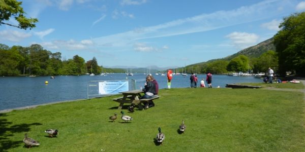
Bardsea Country Park

Distance: 3.5 miles
Location: Bardsea Country Park
Coordinates: N 54.15993, W 3.06950
Bardsea Country Park is a pleasant coastal access area adjacent to the road and near the pretty village of Bardsea. There is plenty of free layby parking alongside the road and some lovely views across Morecambe Bay towards the Lancashire coast and hills. Adjacent to the parking is a grassy area with benches and a pebbly/sandy beach which is fine for a picnic on a good day. At low tide there is a vast area of sand/mud stretching across the bay. You can walk along the beach and to nearby Sea Wood which is a wonderful ancient oak woodland on the coast and good for bluebells in the spring. On the opposite side of the road is a small cafe and separate toilet facilities.
Travelling
Opposite the parking area, next to the toilets, is a minor road which you take to enter the village of Bardsea. Continue through the village, passing Holy Trinity Church on the right, in an imposing position with views over Morecambe Bay. Soon, pass the Ship Inn on the left and just beyond is a left turn to Urswick which you take. The narrow road climbs out of the village and through lush pastures for approx 0.9 miles to cross a cattle grid and on to Birkrigg Common which is predominantly open grass and bracken. There are good views on the right, back towards Ulverston, and a number of places to pull in and admire the area. Continue to a T junction where you turn left, then in a short distance turn left again as the road circumnavigates the Common. Continue to climb for approx 0.3 miles to a small and rough roadside parking area which gives the easiest access to Birkrigg Common summit area.
Birkrigg Common

Distance: 5.6 miles
Location: Birkrigg Common summit
Coordinates: N 54.15735, W 3.09992
Birkrigg Common is a wonderful open access area overlooking the Furness peninsula and Morecambe Bay. The summit is marked with a white trig point and bench. Being one of the highest points on the Furness peninsula, it offers fabulous distant views in all directions, including northwards towards Lake District mountains and southwards towards Blackpool tower on a good day. You can explore the Common via the numerous grassy footpaths which run between limestone features and bracken. The summit is a 5 minute gentle uphill stroll from the stated parking area, although there are plenty of other roadside parking areas giving open access to the whole Common. Parking is all free but no facilities nearby.
Travelling
Continue on the narrow road which soon begins to descend with wonderful open views ahead over Morecambe Bay. Shortly, the road bends through a small settlement and approx 0.2 miles beyond, just past where the wall on the right turns away from the road, there is some rough roadside parking for The Druid’s Circle, still within Birkrigg Common.
Druid's Stone Circle

Distance: 6.3 miles
Location: Druid’s Stone Circle, Birkrigg Common
Coordinates: N 54.15541, W 3.08612
The area around Birkrigg Common contains a number of Bronze Age relics and the Druid’s Stone Circle is one of the more impressive. There are two roughly concentric stone circles, although the outer one is mostly obscured by turf and vegetation. The double circle is quite unique in the UK and evidence indicates that it was used for burials. Although relatively small and not quite complete, it is worth visiting if only for the surrounding views. The circle is approx 100m north of the stated parking area, following the grassy path. Free parking and entry but no facilities nearby and beware of soft verges on the roadside.
Travelling
Continue along the minor road which very soon meets Sea Wood on the right. There is some rough parking and pedestrian access to this attractive ancient oak woodland. The road descends a little more and soon rejoins the A5087 coast road at a T junction where you turn right. The next section of coast road is a delight, passing through Sea Wood, then undulating through green pastures with some fabulous coastal views over Morecambe Bay and ahead towards Blackpool tower in the far distance. Soon, you pass the village of Baycliff on the right and the whitewashed Fishermans Arms Hotel. Continue beyond the village for approx 0.7 miles to a cross roads where you turn left to Aldingham. The minor road soon enters the small village and descends to the coast where there is parking on the left adjacent to the church.
Aldingham

Distance: 8.8 miles
Location: Aldingham
Coordinates: N 54.12990, W 3.09836
Not much remains of the historic village of Aldingham, with apparently much being lost to the sea over the centuries. However, the attractive buildings that remain are in a peaceful setting with wonderful views across Morecambe Bay. St Cuthbert’s Church is directly on the coast and although it has been much extended and restored, the oldest part dates from the 12th century and is worth exploring. Across the road is Aldingham Hall which is now a private nursing home but you can see the fancy exterior from the road. The wide pebbly/sandy beach is adjacent to the car park and at low tide, sand/mud stretches as far as the eye can see. There are adjacent toilet facilities which along with the parking are free but a donation is welcome.
Travelling
Head back the way you came to the cross roads with the A5087 and go straight across towards Gleaston Water Mill. Continue through pleasant open countryside for approx 0.8 miles to the village of Scales. Pass through the peaceful village for approx 0.3 miles to take the first left turn. Continue along the single track road for approx 0.6 miles, passing a small tarn on the left before you see Gleaston Castle ahead on the right. The castle dates from around the 14th century but has been ruined for many centuries and is not open to the public. You get a good view of the castle from the road before passing through the adjoining farm. Continue a short distance to Gleaston Water Mill on the right, with parking on the left.
Gleaston Water Mill

Distance: 11.2 miles
Location: Gleaston Water Mill
Coordinates: N 54.12846, W 3.13355
Slightly off the beaten track, Gleaston Water Mill is an impressive historic water corn mill which has been restored to its former glories. The buildings date from 1774 and have an interesting history although were in a bad way until restoration took place during the 1990’s. You can wonder around the mill and its museum and see the original milling machinery and 18ft waterwheel. There is also a gift shop and next door is Flours cafe. Mill open Wednesday to Sunday, plus bank holiday Mondays, from Easter to end of September. Admission fee applies to mill, including toilets. The free car park is across the road, next to the beck that powered the mill.
Travelling
Leave the car park and turn left to continue on the minor road which shortly enters the village of Gleaston. Soon, meet a T junction where you turn left to head away from the village on a pleasant country lane. In approx 1 mile the road meets the A5087 coast road again at a T junction where you turn right. The main road soon meets and follows the coastline and there are various laybys from where you can fully appreciate the lovely open views across Morecambe Bay. The beach tends to be pebbly/sandy and mostly submerged at high tide, with vast amounts of sand/mud at low tide.
Continue along the coastline road for approx 2.5 miles to a roundabout where you take the first exit to Rampside. Again following the coastline, you soon see a very slender tower on the foreshore which dates from the 19th century and served as a navigation beacon for boats approaching Barrow. The road passes through the village of Rampside, including The Clarke’s Hotel on the right, before bearing left on to a causeway. The causeway leads approx 0.5 miles to Roa Island and about half way along on the left is a mile long spit of land leading to Foulney Island which can be walked at low tide. Continue on the road to Roa Island, passing through the small settlement to some roadside parking at the end of the road.
Roa Island

Distance: 16.8 miles
Location: Roa Island
Coordinates: N 54.07353, W 3.17418
Roa Island is now the most southern part of mainland Cumbria, although until the mid-19th century it was a true island. At that time the causeway was built linking it to the mainland, mainly to allow the Furness railway to connect with steamer ships which stopped at the small island. The railway and steamers are long gone but the island provides some good views towards Walney Island, Piel Island, Barrow and Morecambe Bay.
Nearby, the small but pretty Piel Island can be visited by boat trip from Roa Island. The early monks of Furness Abbey used Piel Island for storage of provisions and defence purposes. They built Piel Castle in the 14th century and you can still visit the impressive ruins. The Ship Inn is one of the few buildings on the island and the landlord is known as the ‘King of Piel’ following historic tradition. There is a regular ferry boat from Roa Island to Piel Island between Easter and September, weather permitting, check the Facebook page to confirm.
Back on Roa Island, there is an impressive lifeboat station at the tip of the island and the nearby Bosun’s Locker cafe provides refreshments. Roadside parking is free but limited. There are public toilets nearby, adjacent to the road.
Travelling
Head back across the causeway, past Rampside, to the roundabout with the A5087 where you take the first exit towards Barrow. The road continues through open countryside for approx 2 miles, passing St Michael’s Church on the left, to enter Barrow-in-Furness and soon meets another roundabout. Take the first exit to continue on the A5087 through the Barrow suburbs for approx 1.3 miles to pass the large St George’s Church on the right overlooking the docks. The road bears right and as you pass Morrisons supermarket on the left, get in the right lane to turn right towards the town centre. Heading towards the Town Hall clock tower, soon meet a roundabout containing a statue of Henry Schneider who was instrumental in the development of Barrow’s steel industry in the mid-19th century. Take the second exit and the road soon bears left to Market Street car park on the right, directly behind the Town Hall.
Barrow-in-Furness

Distance: 22.3 miles
Location: Barrow-in-Furness, Market Street car park
Coordinates: N 54.11078, W 3.22846
The large industrial town of Barrow-in-Furness stands in an isolated but attractive location at the tip of the Furness peninsula. It was just a small fishing village in the early 19th century but was transformed following the arrival of the Furness Railway in 1846 which allowed a large iron and steel industry to develop. As the steelworks boomed, they apparently grew to be the largest in the world. On the back of this, a large shipbuilding industry flourished and docks were built in the sheltered strait between Barrow and Walney Island. The population soared from 450 in 1851 to 47,000 in 1881. Shipbuilding continued to grow, as did the population, reaching a peak of around 82,000 during the first world war. During the second world war Barrow was a target for the German air force who tried to disable the shipyards.
Nowadays the population has decreased to around 56,000. Although not as busy as they once were, the huge shipbuilding works still dominate the town and are renowned for producing some of the most advanced Nuclear Submarines in the world. The town itself isn’t the prettiest but is worth some exploring. The majority of the town centre was planned and built during the boom period and the grid structured wide streets are testament to this. There are some impressive Victorian buildings, including the large Town Hall adjacent to the car park, made from local red sandstone. There is also a good selection of shops, refreshments and a large indoor market. Pay and display car park.
Travelling
Turn left out of the car park and retrace your steps to the Henry Schnieder roundabout where you take the third proper exit. The wide road soon crosses a bridge over the dock area and enters Barrow Island which is home to Barrow Shipyard and many old tenement properties that were originally built for the booming shipyard population. Shortly, meet a roundabout and take the third exit, continuing past more shipyard buildings to meet a further roundabout where you take the first exit to Walney. The road then crosses the impressive Jubilee Bridge over the Walney Channel to enter Walney Island. Turn left at the following traffic lights towards South Walney. The road briefly follows Walney Channel, mostly mud if the tide is out, before heading inland across the narrow island. Pass a tidal inlet on the left and soon the road meets the western shore at Biggar Bank. The road bears left and roadside parking is a short distance on the right.
Walney Island, Biggar Bank

Distance: 24.6 miles
Location: Walney Island, Biggar Bank
Coordinates: N 54.09605, W 3.25708
With over 11,000 residents, Walney Island is one of the most populated islands in the UK. The settlement mostly dates from the boom days of the shipyard and is basically an extension of Barrow town. The long thin island often takes a battering from the Irish Sea but has some wonderful coastal scenery and can easily be reached from Barrow via Jubilee Bridge. At over 10 miles in length, much of the island remains undeveloped and there are numerous coastal access points but Biggar Bank is one of the more scenic and popular. The long beach is pebble/stone with plenty of exposed hard sand at low tide. Behind that is a good area of grass with a few benches and footpaths along the shore. There are excellent views out to sea where you can see the vast offshore windfarms and even the Isle of Man on a good day. Free parking overlooking the sea with nearby Round House cafe and play area. Elsewhere on the island, you can visit South Walney Nature Reserve, popular for bird watching, or North Walney Nature Reserve with some spectacular wild habitats.
Travelling
Retrace your steps to cross back over Jubilee Bridge towards Barrow town. At the roundabout beyond the bridge, take the first exit and continue for approx 0.2 miles to Barrow Dock Museum car park on the left.
Barrow Dock Museum

Distance: 26.2 miles
Location: Barrow Dock Museum
Coordinates: N 54.11181, W 3.23956
Situated over an old dry dock and in the shadow of the massive Devonshire Dock Hall indoor shipbuilding facility is Barrow Dock Museum. This impressive free museum is a great place to discover the interesting history of the local area, including the meteoric rise of Barrow due to steel manufacture and shipbuilding during the 19th century, plus the German bombing of the town and shipyards during the second world war. Long before that there was a Viking influence in the area, before the monks of Furness Abbey settled in the 12th century.
There are various exhibitions, displays and films telling the story and the modern facility makes it an enjoyable experience. The scale models of various ships that have been built in the town are certainly impressive. Outside, there is a landscaped waterfront area with picnic tables, play area and walks alongside Walney Channel. Open all year, Wednesday to Sunday. There is free car parking, a cafe and toilet facilities for visitors.
Travelling
Turn left out of the car park and get in the right lane to continue straight ahead for town centre. Soon, meet a roundabout and take the third exit to pass retail parks on either side of the road. Shortly, take the left filter lane to turn left at the next roundabout, before meeting another roundabout with a statue in the centre. The statue is James Ramsden who was instrumental in the development of Barrow and the Furness Railway in the mid-19th century. Take the second exit at this roundabout and continue on the wide Abbey Road, passing some grand Victorian properties along its length. This road used to be the main route to and from the town before the early 1990’s when the A590 bypass was built.
Soon, approach a large cross roads with traffic lights. On the left is a statue of former Liverpool and England footballer Emlyn Hughes who was born locally. Continue straight ahead, past the main railway station on the left. Once over the railway bridge, on the right is Barrow Park which is a very pleasant parkland area. Continue beyond the park, through the town suburbs on Abbey Road for just over 1 mile to take a right turn, signposted to Furness Abbey. Very shortly, take the next left turn which soon brings you to a T junction overlooking the Abbey. If you turn left, the Abbey visitor centre and entrance are a short distance on the right. Alternatively, turn right at the T junction and a free car park on the right offers some good external views of the Abbey.
Furness Abbey

Distance: 29.1 miles
Location: Furness Abbey
Coordinates: N 54.13708, W 3.19887
The impressive ruins of Furness Abbey stand in a picturesque and peaceful valley on the outskirts of Barrow. Founded in the 12th century, the Abbey soon grew and acquired vast amounts of land as far afield as the Isle of Man, reached by boat via Piel island, and Borrowdale, reached by packhorse trails over the fells. The Abbey eventually became the second richest Cistercian Abbey in England, behind Fountains Abbey in Yorkshire. The period ended in dramatic fashion with the dissolution of the monasteries by King Henry VIII in the 1530’s, when he seized much or their wealth and destroyed most of their buildings.
Much of the huge red sandstone structure has disappeared but there is still plenty to see and English Heritage provides guides telling you more as you wonder around. There is an entrance fee (free for English Heritage members), although a good external view can be had from the adjacent public road, and from the nearby grassy hill, and from Abbey Mill cafe which provides refreshments. Behind the cafe, a short path leads to the 15th century Bow Bridge which carried an old packhorse route over Mill Beck to the Abbey. The Abbey itself has a visitor centre with shop and exhibition, toilets and car park. It is open daily Easter-November, otherwise weekends only.
Travelling
From the Abbey visitor centre, turn right on the minor road and soon meet a T junction where you turn right. In a short distance meet a mini-roundabout and take the first exit. Leaving Barrow behind, continue for approx 1 mile to a roundabout and take the first exit, which is the main A590 towards Barrow. Almost immediately, turn right towards Roanhead and after approx 0.4 miles meet a T junction where you turn left. Continue approx 0.8 miles down the narrow lane, through coastal countryside, to Sandscale Haws car park at the end of the lane.
Sandscale Haws

Distance: 31.9 miles
Location: Sandscale Haws
Coordinates: N 54.16996, W 3.22642
Sandscale Haws is a beautiful National Trust Nature Reserve featuring a sandy/pebbly beach backed by a huge area of sand dune grasslands overlooking the Duddon Estuary. From the car park, boardwalks lead to the nearby beach or in to the dunes. There are lovely views across the Duddon Estuary towards Black Combe mountain and northwards towards central Lakeland mountains. As you walk away from the car park, around the headland, you can also see the nearby northern end of Walney Island.
It is also a significant area for wildlife, including a quarter of the rare Natterjack toads found in the UK. There are migratory bird populations of international importance, including Pintail, Red Knot and Common Redshank. Over 20,000 wintering waterfowl can be seen regularly. If that isn’t enough, it is a paradise for fungus fans with over 300 different kinds recorded in the area, including some extremely rare ones. The car park is free for National Trust members, otherwise pay and display. There is a small visitor centre and nearby toilets.
Travelling
Retrace your steps back up the lane and after approx 0.8 miles take the right turn which soon meets the main A590 where you turn left. Take the first exit at the following roundabout and continue approx 1 mile to another roundabout where you take the third exit towards Dalton. Continue for approx 0.6 miles, through the outskirts of Dalton-in-Furness town, to the old triangular market place on the right with Dalton Castle behind. There are various roadside parking places in the vicinity.
Dalton-in-Furness

Distance: 34.9 miles
Location: Dalton-in-Furness
Coordinates: N 54.15568, W 3.18620
The ancient market town of Dalton-in-Furness was once the major town of the Furness area. Its development owed much to the nearby Furness Abbey and the monks who used the settlement as a centre for administration and justice. The 14th century Dalton Castle was built as a compact Pele Tower for protection against raiders. After the dissolution of the Abbey in 1537, the castle continued as a courthouse for over 300 years and was eventually given to the National Trust in 1965. The castle houses a small free museum but is only open Saturday afternoons from Easter to the end of September. In front of the castle is the old market place with an impressive Victorian drinking fountain and stone cross. Behind the castle is the attractive red sandstone St Mary’s Church. Market Street leads down the hill towards the nearby pleasant town centre which is worth some exploring with its interesting buildings and different shops. Parking at the castle is free.
Travelling
From the castle area, continue down the hill on Market Street and onwards through Dalton-in-Furness town. Just beyond the town, meet a roundabout where you take the second proper exit on the A590 towards Ulverston. Shortly, take the first left turn following the ‘Elephant’ sign and soon arrive at South Lakes Safari Zoo car park on the left.
South Lakes Safari Zoo

Distance: 36.8 miles
Location: South Lakes Safari Zoo
Coordinates: N 54.16791, W 3.16209
South Lakes Safari Zoo is a popular wildlife attraction for all the family. The zoo is adjacent to, but well hidden from, the main A590 and has greatly expanded over the years. There are a huge variety of wildlife around the large site, including big cats, giraffes, rhinos, monkeys and South American birds. In some areas of the zoo you can actually mingle with the less dangerous animals, and various zoo keeper and feeding experiences are available for additional cost. The zoo is open daily all year and there are many facilities, including play area, food outlets, gift shop and toilets. Entrance fee applies.
Travelling
Leave the car park and turn right. Soon, meet the main A590 again at a T junction and turn left towards Ulverston. The road continues through rolling Furness countryside and shortly enters the village of Lindal-in-Furness which has a pleasant village green if you take the first left turn. Lindal was one of many local mining villages supplying iron ore for the Barrow steel industry from the mid 19th century. Continue on the A590 for just over 1 mile to a roundabout and take the second exit to enter the village of Swarthmoor. Continue for approx 0.3 miles and take the first proper right turn, immediately before the Miners Arms pub. The minor road soon leaves the village and enters open countryside with views ahead of the Hoad Monument above Ulverston. Pass a farm on the left and soon Swarthmoor Hall car park is also on the left.
Swarthmoor Hall

Distance: 39.8 miles
Location: Swarthmoor Hall
Coordinates: N 54.18578, W 3.10244
Swarthmoor Hall is an Elizabethan country house owned by the Quaker movement and famous for its strong connections to the early Quakers. Built around 1586, the house soon became the headquarters for the movement as its owners offered protection and hospitality to the early Quakers including the founder member, George Fox. You can find out more with an audio tour of the well preserved house which includes mullioned windows, oak panelling, 17th century furniture and an interesting staircase. Adjacent to the house is a cafe and some attractive and peaceful gardens where you are free to wonder. There is an entrance fee to the house which is open daily from February school holidays to end of October. The gardens and cafe are open all year with free entry. Free parking and toilet facilities.
Travelling
Exit the car park and turn left. The road bears right and soon meets a T junction where you turn left. Enter the residential outskirts of Ulverston town and proceed to another T junction where you turn left again. The road continues a short distance, through a dip, past three schools overlooking each other, then past Ulverston railway station on the left, to a crossroads with traffic lights where you turn right, back on the main A590. Stay in the left lane for the town centre and continue straight ahead through more traffic lights, with the Coronation Hall then the Laurel & Hardy Museum on the left. Soon, meet a roundabout and take the first exit. Brewery Street car park is immediately on the left.
Ulverston

Distance: 41.1 miles
Location: Ulverston, Brewery Street car park
Coordinates: N 54.19605, W 3.09245
Return to start point.