Keswick - Bassenthwaite - Caldbeck drive
A drive from Keswick around the Skiddaw mountain range visiting the northernmost reaches of the Lake District. As well as beautiful lakes and mountains, attractions include picturesque villages, historic buildings and some unique wildlife. 41 miles.
Route Map
Summary of main attractions on route
| Distance | Attraction | Car Park Coordinates |
| 0 miles | Keswick | N 54.59936, W 3.13758 |
| 4.4 miles | Mirehouse & Dodd Wood | N 54.64282, W 3.18703 |
| 8.5 miles | Lake District Wildlife Park | N 54.68360, W 3.23353 |
| 13.9 miles | Uldale Common | N 54.72666, W 3.14543 |
| 18.3 miles | Caldbeck village | N 54.74953, W 3.05270 |
| 20.0 miles | Hesket Newmarket village | N 54.73832, W 3.02373 |
| 22.7 miles | Caldbeck Common | N 54.70572, W 3.00995 |
| 26.4 miles | Mosedale Valley | N 54.68411, W 3.03966 |
| 29.9 miles | Mungrisdale | N 54.66159, W 2.98672 |
| 36.1 miles | Threlkeld Mining Museum | N 54.61292, W 3.04785 |
| 39.5 miles | Castlerigg Stone Circle | N 54.60376, W 3.09811 |
| 41.6 miles | Keswick | N 54.59936, W 3.13758 |
The attraction car park coordinates are available as Points Of Interest (POI) files for your sat nav device. Use the following link to download a zip file containing the most common POI file formats; Keswick – Bassenthwaite – Caldbeck POI. Further information on sat nav files can be found on the Navigation page.
The Drive
Keswick

Distance: 0 miles
Location: Keswick, Central car park
Coordinates: N 54.59936, W 3.13758
Keswick is a popular and pretty tourist town nestled between Derwent Water and Skiddaw mountain. It has long been the main hub for the northern Lake District and boomed when the railway line from Penrith and west Cumbria was completed in 1864, bringing Victorian tourists to Keswick station. You can still see the station today in the northern town but the railway line was closed in 1972. The old railway line is now a popular cycle and walking path alongside the River Greta towards Threlkeld to the east.
An important part of Keswick’s heritage is pencil making and you can visit the interesting Pencil Museum where you will learn all about historic graphite mining in nearby Borrowdale and the growth of pencil making in Keswick through the 19th century. Pencil manufacture moved to nearby Workington in 2008 but the museum remains and you can also see one of the largest colour pencils in the world at almost 26 feet long! Other interesting attractions in the town include Keswick Museum and The Puzzling Place. There are abundant shops, outdoor specialists, cafes, pubs and restaurants around the town as well as some lovely parks. In the town centre is the pedestrianised market place where you might find the market in full swing. In the centre of that is the prominent old Moot Hall which now houses the Tourist Information Centre. Over the River Greta from the town centre, you will find the attractive Fitz Park with it’s vast open grassy areas next to the river where you can escape the crowds.

A 10 minute walk from the town centre is the lakeside area on Derwent Water which is always popular and you can explore the lake, either by boat or the fabulous 10 mile footpath which circuits the lake. The Keswick Launch cruise is a wonderful way to take in the lake and its surroundings. There are regular boats (less in winter) which stop here and at several beauty spots around the lake. It is definitely worth walking the short distance to Friar’s Crag which offers beautiful views up the lake. Crow Park, opposite Lakeside car park, has a lovely open setting next to the lake where you can watch the boats come and go, again with great views. Between Crow Park and the town centre is Hope Park which has delightful landscaped grounds and miniature golf. There is a cafe, toilet facilities and the popular Theatre by the Lake which has its own facilities.
Central car park is very close to the town centre. The lake is less than 10 minute walk but if you want to drive closer to the lake you can park at Lakeside car park which is a little further along the Borrowdale road and turn right at the next mini-roundabout. Central and Lakeside car parks are pay and display.
Travelling
Leave the car park and turn right on the B5289, towards the A66. Shortly pass Booths supermarket and meet a mini-roundabout where you take the first exit, again towards A66. Soon pass the Pencil Museum entrance on the right and cross the River Greta which flooded badly in 2015. Shortly, take the right turn lane towards ‘Carlisle A591’ and turn right. Continue approx 0.4 miles through the town outskirts to a big roundabout with the A66. Take the second exit, A591, towards Carlisle. Continue along the A591 with good views of surrounding scenery, including Skiddaw mountain to the right and then Bassenthwaite Lake to the left. Approx 3.2 miles beyond the roundabout is Dodd Wood car park on the right.
Mirehouse & Dodd Wood

Distance: 4.4 miles
Location: Dodd Wood car park
Coordinates: N 54.64282, W 3.18703
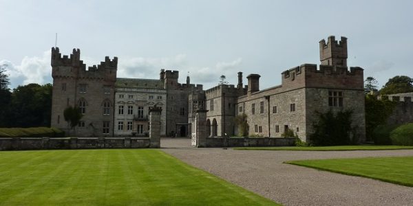
Mirehouse is an historic manor house built in 1688 and owned by the same family since 1802. The house has been extended and renovated and although still largely a private residence, the ground floor is sometimes open to the public. There is an interesting collection of furniture, antiques and manuscripts from eminent writers once connected with the owners. The accompanying live piano music helps enhance the experience.
Outside the house are some attractive gardens and grounds with various adventure playgrounds for the children. The grounds extend to the nearby shores of Bassenthwaite Lake and you can walk along the peaceful lakeshore. Nearby is the tiny St Bega’s Church overlooking the lake which you can also visit. You can pass near the house and visit the church for free by taking the public footpath to the left of the main gate on the A591.
The house is open from Easter to October but only on Wednesday and Thursday afternoons, plus Sundays in August. The grounds are open daily from March to October. Admission fee applies to both. Dodd Wood car park is directly across the A591 from Mirehouse entrance and is ‘pay on exit’, with the first 20 minutes free. Also at the car park are toilets and The Old Sawmill Tearoom where you can buy Mirehouse tickets.

Part of the Mirehouse estate and now managed by the Forestry Commission, Dodd Wood provides some lovely forest walks on the slopes of Dodd Fell. There are some fabulous views over Bassenthwaite Lake and the Derwent valley which only improve as you get above the trees and towards the summit of Dodd Fell at 500m. The wood became popular in 2001 when the first wild Ospreys to breed in the Lake District for over 150 years nested in the area and it became the best place to view them. Since then a pair normally take up residence and breed here each year between April and September before heading to Africa for the winter. There are two viewing areas in the woods, the lower one approx 15 minute uphill walk from the car park and the upper one approx 20 minutes walk beyond that. There are sometimes telescopes and volunteers to help you spot the magnificent birds and with a 5 foot wingspan you might well see them swooping over the lake on their fishing missions.
Travelling
From the car park, turn right on the A591, passing through woodland before views open out across fields towards the northern end of Bassenthwaite Lake. Bassenthwaite Lake is actually the only true ‘lake’ in the Lake District, none of the others have ‘lake’ in the name, they are all meres, waters or tarns. Approx 2.2 miles from the car park, pass St John’s Church with its interesting spire and nearby is Bassenthwaite village. Approx 1.2 miles beyond, approach a junction at the Castle Inn Hotel where you turn left on the B5291. Follow the straight road for approx 0.3 miles to take the first right turn, adjacent to the grand Armathwaite Hall Hotel entrance. A short distance down the dead end road is the car park for Lake District Wildlife Park on the left.
Lake District Wildlife Park

Distance: 8.5 miles
Location: Lake District Wildlife Park
Coordinates: N 54.68360, W 3.23353
The only wildlife park in north Cumbria, Lake District Wildlife Park is a popular but quite well hidden attraction to the north of Bassenthwaite Lake. The Park is home to over 100 different species, mostly the less dangerous varieties such as zebras, monkeys, meerkats and birds of prey. The open site is well laid out making it easy to see and interact with the different animals. There are a number of interesting talks and displays where you can get close to many of the animals. Keeper experiences are also available if you want to get even closer. There is a car park, cafe, shop, picnic areas, play areas and toilets on site. Admission fee applies. Open daily all year.
Travelling
Return to the B5291. The drive continues by turning left but if you turn right a short diversion takes you approx 1 mile, over the River Derwent, to The Lakes Distillery which is an interesting attraction. Otherwise, the drive returns to the A591 at the Castle Inn Hotel junction where you turn right then immediate left towards Uldale. The quiet road generally climbs through rolling countryside with views towards Skiddaw on the right which might include Whitewater Dash waterfall after rain.
Approx 2.5 miles beyond the Castle Inn Hotel, the road begins to descend towards Uldale and on the left are distant views towards the Solway Firth and southern Scotland. Soon enter the small and pleasant village of Uldale with its village green. Although there isn’t much to see, you could stop for refreshments at the Snooty Fox Inn or Mae’s Tearoom. Continuing beyond the village, cross a cattle grid and the road climbs steeply towards Uldale Common with better views towards Scotland on the left. As the road levels out you are surrounded by open moorland and shortly you see a small parking area on the left where you can stop and admire the views.
Uldale Common

Distance: 13.9 miles
Location: Uldale Common, Back o’ Skiddaw
Coordinates: N 54.72666, W 3.14543
It is worth stopping at this lofty layby to admire the picturesque and tranquil surroundings. Better views can be had by climbing the small grassy lumps just behind the parking area. Looking south, the peak of Skiddaw mountain can be seen in the distance, with some northern Lakeland peaks visible beyond that. In the nearer distance are various lower hills known locally as ‘Back o’ Skiddaw’, including the Uldale Fells and Caldbeck Fells. The immediate surroundings are rough open moorland, a rare sight when driving in the Lake District. Free parking but no facilities. Nearest facilities at Caldbeck village.
Travelling
Continue along the open road which gradually descends with pleasant surrounding moorland views. After approx 2.5 miles, a cattle grid marks the end of the open moor and the road continues through farmland. A further 1.3 miles takes you to the outskirts of Caldbeck village. Continue to the village centre and take a left turn on the B5299 towards Wigton, adjacent to the Old Smithy Tea Room. Continue a short distance, passing the attractive houses and stream on the left, to cross a larger river. The village car park is over the bridge on the left.
Caldbeck

Distance: 18.3 miles
Location: Caldbeck village car park
Coordinates: N 54.74953, W 3.05270
The picturesque and historic village of Caldbeck is the most northerly village in the Lake District National Park and one of the most remote. There are a number of attractions for visitors which are worth some exploring. Around the village centre you will find the attractive St Kentigern’s church and next door is Priest’s Mill, a former cornmill which has been well restored as an arts, crafts and gifts centre including The Watermill Cafe. A short riverside walk follows Cald Beck downstream from the car park to the mill.
A short riverside walk in the opposite direction from the car park leads to The Howk, an impressive limestone gorge containing a picturesque waterfall and an old Bobbin Mill ruin. On the edge of the village above the car park is the large green and pond which provides a pleasant place to stroll and relax. Refreshments can also be obtained at the village shop, the Oddfellows Arms pub and The Old Smithy Tea Room. Free car park and public toilets in the village.
Travelling
Leave the car park via the one way system, turning right past the village green, then right again back to the car park entrance. Continue to the junction adjacent to the Old Smithy Tea Room and turn left towards Hesket Newmarket. Continue though Calbeck village and soon enter open countryside. Approx 1 mile beyond Caldbeck, enter the village of Hesket Newmarket. The road soon bears left and arrives at the top of the long village green. At the far end of the village green, the village car park is beyond the last building on the right.
Hesket Newmarket

Distance: 20.0 miles
Location: Hesket Newmarket village car park
Coordinates: N 54.73832, W 3.02373
Another pretty and peaceful north Lakeland village which is worth a closer look. The main village surrounds the long attractive green with a number of interesting and historic buildings. The Old Crown pub overlooking the green is famous for being co-operatively owned by locals and home of the popular Hesket Newmarket Brewery. Further up the green is the village shop which incorporates a tea room and post office. Opposite the shop is Hesket Hall, a 17th century building with some interesting features and a large central chimney. Free car park.
Travelling
Turn right out of the car park, leaving the village to enter open countryside. After approx 0.3 miles, take the right turn signposted to Mungrisedale. Continue generally up hill on the minor road for approx 1 mile to a left turn for Mungrisedale. Ignore this left turn and continue straight ahead for better views. The road narrows and continues to climb for approx 0.6 miles to a small summit from where wonderful views open up ahead. Continue over a cattle grid and enter the unfenced Caldbeck Common. In a short distance, descend to ford the pretty Carrock Beck, although if water levels are high you may need to turn around and take the previously mentioned Mungrisedale turn. Just beyond the ford is some open grass where you can park on the Common.
Caldbeck Common

Distance: 22.7 miles
Location: Caldbeck Common
Coordinates: N 54.70572, W 3.00995
Another lofty area of moorland, Caldbeck Common provides a pleasant place to stop and admire the surrounding views. The open area is a mixture of grass and bracken and there are various places where you can park on the roadside. The views south and east are impressive with the mighty Carrock Fell overlooking the Caldew valley below and further hills visible in the distance. The distinct change where the steep Caldbeck Fells meet the flatter lands to the east is obvious from here. You may also see the wild black ponies that live on the Common. Free parking but no facilities.
Travelling
Continue down the open road and soon meet a T junction where you turn right. Continue approx 1.5 miles to enter the small hamlet of Mosedale where you take the right turn signposted to Swineside. This dead end narrow road follows the attractive River Caldew valley for approx 1.8 miles to a rough roadside parking area next to the river.
Mosedale

Distance: 26.4 miles
Location: Mosedale Valley
Coordinates: N 54.68411, W 3.03966
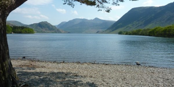
The remote and beautiful Mosedale valley can be appreciated in this small detour and the parking area provides a good place to picnic, relax and take in the surroundings next to the open river. The steep valley sides lead to some high mountains nearby, including Carrock Fell to the north and Bowscale Fell to the south, either can be climbed from nearby footpaths. The River Caldew and a popular bridleway continue for a few miles up the valley to the very remote Skiddaw House hostel. The impressive valley can also generate a lot of water in a storm and the River Caldew has been known to flood parts of Carlisle in the past. The tarmac road does continue a little way beyond the parking area but it soon becomes rough and turning around can be difficult. Free parking but no facilities.
Travelling
Retrace your steps to Mosedale and turn right at the T junction in the hamlet. Cross the River Caldew, through the hamlet of Bowscale and the road again follows the line between the steep mountain slopes on the right and the flatter lands on the left. Shortly, enter the village of Mungrisdale, passing St Kentigern’s church on the left and continuing to the village hall on the left with the River Glenderamackin on the right. You can park here for a small charge but approx 0.1 miles further on is a free roadside parking area next to the river.
Mungrisdale

Distance: 29.9 miles
Location: Mungrisdale
Coordinates: N 54.66159, W 2.98672
Mungrisdale is a small village on the River Glenderamackin in the shadow of some high mountains, including Blencathra and Bowscale Fell. Although not much to see, it has a few attractive old buildings, including St Kentigern’s Church and is a popular base for walking. The Mill Inn provides refreshments in a picturesque setting. The free parking area just outside the village provides a pleasant grassy area overlooking the river.
Travelling
Continue southwards, passing through pleasant open country with good views ahead towards the mountains above Matterdale, including Great Dodd. After approx 1.8 miles, meet a T junction with the main A66 and turn right towards Keswick. Continue on the A66 with views of Blencathra mountain ahead to the right. After approx 1.6 miles, pass the White Horse Inn on the right and a further 1.8 miles beyond, take a left turn on the B5322 towards Thirlmere. Soon cross the River Glenderamackin, then shortly pass between two stone bridge abutments which until 1972 carried the Penrith to Keswick railway over the road. Immediately beyond these, turn left, signposted to the Mining Museum. Follow the minor road, past the Lake District National Park Authority Northern Area Office, for approx 0.3 miles to the Mining Museum entrance and parking.
Threlkeld Quarry & Mining Museum

Distance: 36.1 miles
Location: Threlkeld Quarry & Mining Museum
Coordinates: N 54.61292, W 3.04785
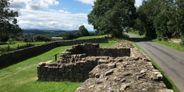
Threlkeld Quarry & Mining Museum is situated in an old microgranite quarry which operated from the 1870’s to 1980’s. Since the early 1990’s the site has been developed as a museum by enthusiasts and provides a fascinating insight into local quarrying and mining. The site is covered in old quarry machinery and vintage excavators cared for by the Vintage Excavator Trust who are based here. A narrow gauge railway with steam and diesel locomotives will transport you around the site to view these machines and you are free to wonder around for a better look.
There is also a museum building with a fine collection of small mining and quarrying artefacts and nearby an old copper/lead mine has been reconstructed where you can experience conditions in a typical local mine. The open sloping site gives superb views across the valley towards Blencathra mountain. Admission fee applies. Open daily from Easter to end of October, except Mondays during school term time. Parking and toilet facilities provided.
Travelling
Retrace your steps back to the B5322 and turn right to pass between the railway bridge abutments again. Continue to a T junction with the main A66 and turn left towards Keswick. In approx 0.4 miles, take the first left turn, signposted to Castlerigg Stone Circle. The road descends to cross the River Greta where there is some roadside parking and a good woodland walk following the river downstream along the old railway line towards Keswick. Continue along the minor country road with wonderful surrounding views for approx 0.9 miles to take a left turn, again signposted to Castlerigg Stone Circle. The road loops around a short distance to another left turn which you take. Continue mostly up hill, passing Keswick Climbing Wall, for approx 0.6 miles to Castlerigg Stone Circle on the left, parking is roadside on the right.
Castlerigg Stone Circle

Distance: 39.5 miles
Location: Castlerigg Stone Circle
Coordinates: N 54.60376, W 3.09811
Castlerigg stone circle is one of the oldest, most famous and most impressive prehistoric stone circles in the country. It is believed the 38 stones were brought to this elevated place by Neolithic farming communities around 4500 years ago. Quite how they got here and their purpose remain something of a mystery, but it would have been an important meeting place for the scattered Neolithic communities, possibly as a trading place, a religious centre or an astronomical observatory. The high open setting certainly enhances the experience, with fantastic 360 degree panoramic views over the northern Lake District, including many notable mountains such as Helvellyn, Skiddaw and Blencathra.
It became a popular tourist attraction in Victorian times but some visitors would chip bits of rock away for souvenirs. This resulted in a campaign for its protection and it became one of the earliest ancient scheduled monuments in the country in 1882. Later, it was acquired by the National Trust and now remains a popular attraction where you can wonder inbetween the stones and soak up the wonderful atmosphere.
Pedestrian access is in the field opposite the free roadside parking. Free entry but no other facilities.
Travelling
Continue along the minor road which generally descends towards the outskirts of Keswick with good views ahead towards the hills around Derwent Water. After approx 0.7 miles, meet a T junction and turn left, then almost immediately meet another T junction and turn right on the A5271 towards Keswick town centre. The road soon follows the River Greta on the right before entering the town centre area. After a couple of sharp bends there is a mini-roundabout where you turn left on the B5289. Follow this for approx 0.3 miles until you reach Keswick central car park on the left.
Keswick

Distance: 41.6 miles
Location: Keswick central car park
Coordinates: N 54.59936, W 3.13758
Return to start point.