Kendal - Sedbergh - Arnside drive
A drive around south east Cumbria which includes a number of interesting old market towns, picturesque rivers and valleys within the Yorkshire Dales National Park and an Area of Outstanding Natural Beauty around Arnside. 56 miles.
Route Map
Summary of main attractions on route
| Distance | Attraction | Car Park Coordinates |
| 0 miles | Kendal | N 54.33013, W 2.74567 |
| 9.1 miles | Killington New Bridge | N 54.31136, W 2.58144 |
| 10.8 miles | Brigflatts Meeting House | N 54.31638, W 2.55374 |
| 12.1 miles | Sedbergh | N 54.32403, W 2.52606 |
| 17.8 miles | Dent Village | N 54.27835, W 2.45568 |
| 22.2 miles | Barbondale | N 54.24257, W 2.52481 |
| 27.7 miles | Kirkby Lonsdale | N 54.20185, W 2.59654 |
| 32.5 miles | Hutton Roof Crags | N 54.17892, W 2.68776 |
| 36.8 miles | Lakeland Wildlife Oasis | N 54.19400, W 2.75384 |
| 38.4 miles | Heron Corn Mill | N 54.21264, W 2.77482 |
| 42.4 miles | Arnside Village | N 54.20388, W 2.83102 |
| 48.2 miles | Levens Hall & Gardens | N 54.25987, W 2.77526 |
| 50.5 miles | Sizergh Castle & Gardens | N 54.27951, W 2.76822 |
| 55.9 miles | Kendal | N 54.33013, W 2.74567 |
The attraction car park coordinates are available as Points Of Interest (POI) files for your sat nav device. Use the following link to download a zip file containing the most common POI file formats; Kendal – Sedbergh – Arnside POI. Further information on sat nav files can be found on the Navigation page.
The Drive
Kendal
Distance: 0 miles
Location: Kendal, Westmorland Shopping Centre car park
Coordinates: N 54.33013, W 2.74567
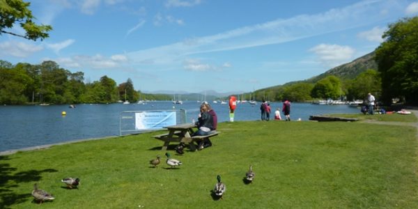
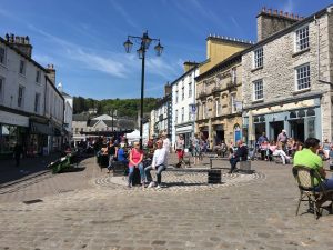
The historic market town of Kendal, located at the south east Lake District boundary, is often referred to as ‘the gateway to the Lakes’ due to its position, or ‘the auld grey town’ due to the many old limestone buildings (rather than the climate!). Its other claim to fame is of course Kendal Mintcake which has long supported mountaineers and walkers worldwide. Lake District visitors often miss the town as they speed past on the A591 bypass, but it is an interesting place to explore with a number of attractions.
The town has a myriad of old alleys and buildings and there are plenty of good shops, cafes and pubs. The River Kent runs through the town with pleasant walks along its banks. Castle Hill, across the river from the town centre, is home to the ruined Kendal Castle and has some wonderful views over the surrounding area. At the southern end of the town centre is the huge Parish Church, Museum of Lakeland Life & Industry and Abbot Hall Art Gallery. Also worth visiting is Kendal Museum and The Brewery Arts Centre which has an interesting and varied selection of events. Pay and display multistorey car park with toilet facilities.
Travelling
Turn left out of the multistorey car park then right at the nearby traffic lights, following signs to Sedbergh A684. Continue over the River Kent and soon approach a mini-roundabout adjacent to Kendal railway station where you get in the right lane to take the second exit. Shortly, take the first left turn and continue past The Castle pub, then straight ahead at a T junction. Pass under a railway bridge and continue through Kendal suburbs.
Beyond the Castle Green Hotel, you soon leave the town behind and start to ascend steeply. Once over the minor summit, the road meanders through undulating countryside with pleasant views over lush pastures towards distant hills. Approx 5 miles beyond Kendal, cross the M6 motorway and continue through a twisty section which leads to the top of a steep hill, with wonderful views ahead towards the Howgill fells and Yorkshire Dales. At the bottom of the hill, take the right turn on the B6256, immediately before the house with a black horse on the front. Continue approx 0.6 miles to roadside parking at Killington New Bridge where it crosses the River Lune.
Killington New Bridge

Distance: 9.1 miles
Location: Killington New Bridge
Coordinates: N 54.31136, W 2.58144
Killington New Bridge is a nature reserve and riverside access area overlooking the attractive River Lune where it passes through a deep gorge, just inside the Yorkshire Dales National Park. A good level footpath with wheelchair access runs the length of the reserve, 600m upstream from the bridge, following the wooded riverbank. There are various seats along the way where you can stop and enjoy the peaceful surroundings and river views. The surrounding hedgerows are a haven for wildlife, especially birdlife.
The impressive gorge carries the river between steep riverbanks and rocky cliffs with some very deep pools in places. The area is popular with local bathers in good weather but access to the river is tricky and the water contains plenty of hazards. A rough footpath continues northwards beyond the nature reserve across pleasant fields. Free entry and roadside parking at the bridge but no facilities.
Travelling
Continue along the hedge-lined minor road and shortly meet a T junction where you turn left on the A683. The road passes through open countryside near the River Rawthey for approx 1.2 miles to a lay-by on the left, opposite the minor road to Brigflatts.
Brigflatts Meeting House

Distance: 10.8 miles
Location: Brigflatts Meeting House
Coordinates: N 54.31638, W 2.55374
The historic Brigflatts Quaker Meeting House is a wonderful building in a peaceful rural location. The building dates back to 1675 when the original Quaker movement was prominent in the local area, as was its founder member George Fox. The building has had some additions and restoration over the years but the timber interior is largely as original and forms a delightful atmospheric space. Outside, there is a small attractive garden and a visitor toilet. Inside and out you can sit and enjoy the peaceful surroundings. The Meeting House is still used for worship but is otherwise open to the public daily. There is very limited parking near the Meeting House and visitors are requested to park in the lay-by on the main road and walk the short distance down the access lane. Free parking and entry.
Travelling
Continue on the A683 and shortly meet a T junction where you turn right for Sedbergh, back on the A684. Immediately enter Sedbergh town and continue approx 0.6 miles to a narrow section, followed by The Dalesman Country Inn on the left. Immediately beyond this, take the left turn on to Main Street. The narrow one-way street passes through the town centre. Soon, take the first left turn and Joss Lane car park is immediately on the right.
Sedbergh

Distance: 12.1 miles
Location: Sedbergh, Joss Lane car park
Coordinates: N 54.32403, W 2.52606
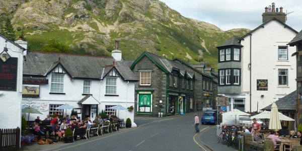
The historic market town of Sedbergh is just inside the Yorkshire Dales National Park and yet still within Cumbria. It was in Yorkshire until county boundary changes in 1974. The pretty town is in a beautiful position surrounded by hills and rivers with a number of attractions for visitors. It is England’s first Book Town and there are several outlets selling second-hand and antiquarian books. There are a number of other shops, cafes, pubs and the historic St Andrew’s Church in the town centre. There is also a famous public school with many attractive school buildings and sports fields scattered around the town.
There are some great short walks through the town and down towards the picturesque River Rawthey. Behind Westwood Books, a short steep path leads up to Castlehaw, once the site of a motte and bailey Norman castle dating from the 11th century, now a good viewpoint. Behind that the steep slopes lead up the Howgill fells which are popular with walkers. A short drive beyond the town is Fairfield Mill, a restored Victorian woollen mill which has heritage displays and exhibitions. Pay and display car park with adjacent toilets.
Travelling
Turn left out of the car park and immediate left again, back on the one-way Main Street. Soon approach a T junction, turn sharp right and continue past school sports fields on the left to a mini-roundabout where you take the first exit towards Dent. Beyond the town limits, the road descends to cross the River Rawthey on a narrow bridge. Shortly, pass the local golf club and the road bears left into Dentdale valley. Continue along the valley road with beautiful views across surrounding fields, woodland, hills and the River Dee. The road is narrow in places and some care is needed. Approx 4 miles beyond the River Rawthey crossing, you cross the River Dee on the narrow Barth Bridge. Continue approx 0.7 miles to enter Dent village, the main car park is a short distance on the left.
Dent

Distance: 17.8 miles
Location: Dent Village
Coordinates: N 54.27835, W 2.45568
The pretty village of Dent is also within the Yorkshire Dales National Park but still within Cumbria. The narrow cobbled Main Street with its tightly packed houses is a delight and the historic St Andrew’s Church offers lovely views across Dentdale valley from the churchyard where you will also find the old grammar school building. The compact Dent Heritage Centre tells the interesting history of the area, including farming and hand knitting, a local speciality in the 18th century. The granite fountain in the village centre is a memorial to Adam Sedgwick, the ‘Father of Geology’ who came from the village.
Refreshments can be obtained from The George & Dragon Hotel, The Sun Inn or Meadowside cafe. Dent Stores provides some provisions. Dentdale itself is a picturesque and peaceful valley, with lush green fields and the meandering River Dee, all enclosed by high hills. There are various walks along the river or up the surrounding hills. Pay and display car park with adjacent picnic tables and toilet facilities.
Travelling
Leave the car park and turn right to retrace your steps down the valley for approx 0.6 miles before taking the first left turn for Barbon. The road starts to climb through the pretty hamlet of Gawthrop. Soon, cross a small bridge and turn immediate left to Barbon. The narrow road ascends steeply out of Dentdale and soon passes over a summit and into Barbondale. The road then gradually descends with dry stone walls either side and wonderful views across the narrow open valley. Approx 1.4 miles beyond the summit, cross a cattle grid and the road opens up on the right with Barbon Beck nearby. Another 1 mile ahead, the road drops down alongside the beck and there are various open grassy areas by the roadside where it is possible to park.
Barbondale

Distance: 22.2 miles
Location: Barbondale
Coordinates: N 54.24257, W 2.52481
Barbondale is an attractive and peaceful valley which carries Barbon Beck towards the River Lune. The road along the valley floor gives great open views, including the steep, grassy and stony slopes which stretch up towards the high peaks on either side. Midway down the valley, the road runs alongside the beck and there are a few small roadside parking areas with a strip of grass alongside the beck where you can sit, picnic and paddle. Since 1st August 2016, the whole valley is now within the Yorkshire Dales National Park after boundaries were extended. Nevertheless, it isn’t well known so is normally a peaceful and pleasant place to enjoy. Free roadside parking but no facilities.
Travelling
Continue down the attractive valley road and after approx 1.5 miles take the first left turn towards Kirkby Lonsdale. The narrow open road gives good views across the Lune valley before crossing a cattle grid to a more enclosed section. Continue approx 1 mile to a T junction and turn right. Soon meet another T junction and turn left on the wider A683. Shortly, pass through the village of Casterton with The Pheasant Inn on the right. Beyond the village, the road descends towards the River Lune and soon passes Devil’s Bridge and a small car park on the right, often filled with motorbikes at weekends. At the following T junction, turn right on the A65. Cross the river on a more modern bridge, beyond on the right is a large grassy picnic area overlooking Devil’s Bridge with adjacent parking. Just beyond that, take the right turn for Kirkby Lonsdale. Immediately enter the town and Market Square car park is a short distance on the right. Further car parks are available up the hill opposite.
Kirkby Lonsdale

Distance: 27.7 miles
Location: Kirkby Lonsdale
Coordinates: N 54.20185, W 2.59654
Kirkby Lonsdale is a wonderful old market town overlooking the Lune valley. Main Street runs through the centre of the town with its quirky shops, pubs and restaurants. The historic Market Square holds a market every Thursday and around the town you will find many historic buildings, cobbled courtyards and passageways which are all worth exploring. At the northern end of the town is the attractive St Mary’s Church, parts of which date back to Norman times. Beyond the pretty churchyard is Ruskin’s view, a fabulous viewpoint over the River Lune valley which the famous Victorian art critic John Ruskin once described as “one of the loveliest in England, therefore in the world”.
Just outside the town is the famous Devil’s Bridge, a spectacular 14th century historic bridge over the River Lune and a popular gathering place for bikers. Adjacent is Jubilee Park, a good open area of grass with picnic tables and benches overlooking the river. From Devil’s Bridge you can follow the river upstream on a good footpath which eventually enters the town via some steep steps. Parking is free at Devil’s Bridge, pay and display in the town. Toilets at Devil’s Bridge and just off Market Square.
Travelling
Leave Market Square and return the way you came along Main Street, back to the A65. Turn left on the A65 then immediate right on the B6254 towards Whittington. The hedge lined road enters Lancashire briefly as it continues down the Lune valley through open countryside with pleasant views across surrounding pastures. To the left you might see the flat top of Ingleborough mountain in the distance, which at 723m is the second highest mountain in the Yorkshire Dales and one of the famous Yorkshire 3 peaks. After approx 1.5 miles, enter the attractive village of Whittington and soon take the right turn towards Hutton Roof where the main road bears sharp left. The road starts climbing through the village, passing the impressive looking St Michael’s Church on the left and then Whittington Hall, hidden from view. Continue climbing away from the village into more open country with good surrounding views. As the climbing eases the road re-enters Cumbria with a timber yard on the left which always has huge piles of logs outside. Continue along the lofty undulating road, with views towards Hutton Roof Crags on the right, for another 1.5 miles to Plain Quarry car park on the right, just beyond a final small summit.
Hutton Roof Crags

Distance: 32.5 miles
Location: Hutton Roof Crags & Dalton Crags, Plain Quarry car park
Coordinates: N 54.17892, W 2.68776
Hutton Roof Crags & Dalton Crags form part of a vast elevated area of natural limestone habitat with far reaching views. The area is best known for its spectacular limestone pavement which is interspersed by attractive crags, woodland, grassland and scrub. The car park is in an old quarry where there is also a secluded picnic area. A fairly rough but pleasing footpath leads through the adjacent woodland and soon starts to climb steadily. Various smaller paths might cause some confusion but generally head up hill away from the car park. Soon, wonderful views open up towards Morecambe Bay and after approx 1 mile you reach the summit trig point of Hutton Roof Crags. Views can be slightly restricted by vegetation but the impressive panorama also includes the Lake District, Yorkshire Dales and Forest of Bowland. Various paths continue, exploring the summit area and its fabulous scenery. Free parking but no facilities.
Travelling
Leave the car park, turn right and descend through woodland, then more open pastures. After approx 1.5 miles enter the outskirts of Burton-in-Kendal village and soon reach a T junction. Turn left on the A6070, then almost immediate right towards Yealand. The road soon crosses the M6 motorway, the Lancaster canal and the main west coast railway line in quick succession, between them providing vital transport links across North West England for over 200 years. Just beyond the railway on the right is Cinderbarrow picnic site which is a pleasant grassy area with a few picnic tables. Here, you will also find Cinderbarrow miniature railway, only open Sundays and bank holidays between Easter and October, but a great little attraction. Immediately beyond this is a T junction where you turn right on the main A6. Continue approx 1 mile through more farmland to pass a service station with shop on the left. Just beyond that, take the first left turn to Lakeland Wildlife Oasis which is immediately on the left.
Lakeland Wildlife Oasis

Distance: 36.8 miles
Location: Lakeland Wildlife Oasis
Coordinates: N 54.19400, W 2.75384
Lakeland Wildlife Oasis is a small zoo adjacent to (but well hidden from) the main A6 road. Although it only covers a small area there are plenty of animals and exhibits on show. Outside, the highlight is probably the wonderful snow leopards, who sometimes like to sit on top of the perspex walkway. Other animals outside include meerkats, lemurs and snowy owls. There are a surprising amount of things to see and do inside which is good for wet weather. The lushly planted tropical hall includes bats hanging above your head, insects, birds, amphibians and reptiles. You can get very close to some species and for an additional fee there are various ‘animal experiences’ available if you want to get even closer. Admission fee applies. Cafe, picnic facilities, toilets and parking included. Open daily all year.
Travelling
Turn right out of the car park and immediate left on the A6 towards Kendal. Soon, pass by the small village of Hale with the The Tavern pub on the right, then not far beyond is the local crematorium on the left, adjacent to the remains of historic Beetham Hall. Just beyond, enter the village of Beetham and take the second left turn to the village, then immediate right which leads down a short dead end lane to Heron Corn Mill.
Heron Corn Mill

Distance: 38.4 miles
Location: Heron Corn Mill
Coordinates: N 54.21264, W 2.77482
Heron Corn Mill is a restored working corn mill at a natural waterfall on the River Bela. The current building dates from the 18th century and until commercial milling ceased in the 1950’s, corn milling had been a feature of the area for over 900 years. The mill was restored and opened to the public in 1975, further restoration took place in 2013/14 to the present standard. You can visit the historic mill building, wander around the different rooms and see the impressive machinery. The massive waterwheel turns the machinery most days that the mill is open and guides can talk you through it. Full milling demonstrations take place on the first Friday of every month. Outside is the modern hydroelectric power plant which is also fascinating. The mill and adjacent barn often host various exhibitions and events. The mill is open all year, Wednesday to Sunday, plus bank holiday Mondays. A small donation is welcomed for parking and admission. Fee applies to milling demonstration. Light refreshments, picnic tables and toilets are also available. Adjacent to the parking area, a footpath leads into the attractive Dallam Deer Park where you might see the local deer herd as you follow the River Bela downstream.
Travelling
Head back along the access lane to the T junction at the end and turn right into Beetham village. The attractive village includes The Wheatsheaf Hotel, St Michael & All Angles Church and a post office shop with tea room. Continue beyond the village and climb on a narrow road through the hamlet of Slackhead. At the top of the hill take the first right turn towards Arnside. This wonderful limestone area, with its mixture of limestone features, hills, valleys, woodland and pastures, is within the Arnside & Silverdale Area of Outstanding Natural Beauty. The road generally descends with some quite well hidden big houses on the right, and after approx 1 mile meet a T junction where you turn right. Shortly, take the first right turn towards Arnside and continue between trees and hedges, eventually with views ahead towards the wooded slopes of Arnside Knott. Soon, cross a railway line at a level crossing and enter Arnside village. After approx 0.6 miles, pass the railway station on the right and roadside parking begins, continuing all along the promenade road.
Arnside

Distance: 42.4 miles
Location: Arnside Village
Coordinates: N 54.20388, W 2.83102
Arnside is an attractive small Victorian resort on the River Kent estuary in the upper reaches of Morecambe Bay. The main attraction is the short promenade along the shoreline which provides a pleasant stroll. There are a few small shops, cafes and a couple of pubs which make the most of the fabulous views across the estuary and beyond towards the Lake District mountains. The village was once a small port and the small pier remains with some pleasant seating. Another feature is the impressive railway viaduct which takes trains across the estuary to Grange over Sands.
The shape of the estuary and high tidal range mean the tide can come in very quickly which sometimes results in a small tidal bore. A siren warns of this event. When the tide is out there are vast expanses of sand and mud across the estuary, either side of the River Kent channel. The village is within the Arnside and Silverdale Area of Outstanding Natural Beauty, an area with wonderful flora, fauna, limestone and coastal scenery. There are some great walks around Arnside, including along the shoreline or up Arnside Knott behind the village which provides superb views over Morecambe Bay. Free parking along the promenade and toilet facilities.
Travelling
Retrace your steps back past the railway station and take the first left turn to Milnthorpe on the B5282, passing underneath the railway. Shortly, on the left through trees is an embankment which once carried a railway line between Arnside and the main west coast line heading north. The line is long gone but it is now a pleasant footpath alongside the estuary and helps prevent this low lying land from tidal flooding. Soon, pass Carr Bank Garden Centre on the right and continue to a sharp bend bridge over the old railway line.
The next section is a delight alongside the River Kent estuary. There are fabulous views across the estuary and towards the hills beyond, best appreciated from the roadside parking along the first section. Beware, this road can actually flood during very high tides. Pass through the shoreline community of Sandside before the road turns inland and soon crosses a bridge over the River Bela with views right of the impressive Dallam Tower house and Deer Park. Shortly, enter Milnthorpe village and continue past Booths supermarket to the traffic lights. The pleasant Market Square is straight across from the lights and is worth a look. Otherwise, turn left at the traffic lights on the A6 towards Kendal. Climb out of the village and soon pass the village of Heversham on the right. Not far beyond, the carriageway splits with trees down the middle and the high garden walls of Levens Hall on the left. At the end of this high wall, take the left turn through the gates to Levens Hall and car park.
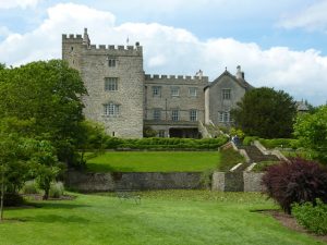
Levens Hall

Distance: 48.2 miles
Location: Levens Hall & Gardens
Coordinates: N 54.25987, W 2.77526
Levens Hall is a fabulous stately home and estate with world famous gardens. Home to the Bagot family since the late 19th century, you can tour certain parts of the house, admire its ornate interior and learn its fascinating history, from its origins as a 13th century Pele tower. House guides are on hand to tell you more along the way. Outside, the main attraction is the large ancient topiary garden which dates from the late 17th century and is apparently the oldest in the world. There are some wonderful shapes to behold and it is well worth a visit.
The estate extends across the A6 to Levens Park which follows the picturesque River Kent upstream and provides an enjoyable walk in parkland occupied by deer and rare Bagot goats. There is also a cafe, gift shop, toilets and free car park for visitors. House and gardens open daily, except Saturdays, from Easter to October. Cafe and gift shop open daily all year, except late December and early January. Admission fee applies to house and gardens.
Travelling
Exit Levens Hall car park and turn left on the A6. The road crosses the River Kent, around a couple of bends and soon passes under the A590 dual carriageway. Immediately beyond the bridge, take the right turn on the A590 slip road towards Kendal. Join the A590 for approx 0.7 miles, past a left turn to Heaves, and take the next left turn to Sizergh Castle. Shortly, pass the popular Strickland Arms pub on the left and continue straight ahead to enter Sizergh Castle estate entrance. The car park is a short drive ahead on the left.
Sizergh Castle
Distance: 50.5 miles
Location: Sizergh Castle & Gardens
Coordinates: N 54.27951, W 2.76822
Sizergh Castle is an impressive stately home and estate, now owned by the National Trust but occupied by the Strickland family since the 13th century. It is very close to the main A591 but well hidden from the road and is well worth exploring. Originally just a Pele tower, the house has been extended over the centuries to provide a home to the owners but you can still tour much of the property and there are volunteer guides to help you.
Outside, there is a lovely garden, including a limestone rock garden and a large pond in front of the castle. Beyond this there are some good walks around the huge estate. There is also a cafe, gift shop, picnic tables and toilets adjacent to the large National Trust pay and display car park. Castle open daily, except Mondays, from March to October. Open Bank Holiday Mondays. Gardens, shop, cafe open daily except early January. Admission fee applies.
Travelling
Retrace your steps back to the road entrance gate. A short detour left here takes you to Low Sizergh Barn, a popular farm shop. Otherwise, continue past the Strickland Arms pub to the A590 and turn left. Immediately meet a roundabout and take the first exit to Kendal. Join the A591 dual carriageway for approx 1.5 miles, through a tree lined section and past a service station and shop, before taking the first main exit to Kendal.
Shortly, enter the outskirts of Kendal town and continue through one set of traffic lights to the start of the one-way system by the river. Get in the right lane and continue approx 0.4 miles through the town centre to the Town Hall where the road bears right, down to the river again. The road soon turns away from the river and ahead, through a couple of pedestrian crossings, you can see the bus station and Westmorland Shopping Centre multistorey car park on the left. The car park entrance is the first left turn immediately beyond the bus station.
Kendal

Distance: 55.9 miles
Location: Kendal, Westmorland Shopping Centre car park
Coordinates: N 54.33013, W 2.74567
Return to start point.